

|
|
These last six days have been a complete and utter thrill for Winter weather lovers all across UK and Ireland, and for those who don't love the Winter weather, plenty of people have been checking their watches and looking out the window waiting for the sun to come out. We have just experienced our most severe Winter weather for this time of year for decades. I have observed and photographed so many cool sights that I'm really finding it difficult to keep up with what's been going on. To summarize it has been snowing on and off every day and night with black ice on the ground and a new record low November temp of - 9.5 degrees C, a figure which was recorded at Lough Fea during the early hours of Sunday November 28th. I was actually out that night until after 03.00 and experienced this severe temp first hand which was a fun experience, despite the dead calm conditions the severe frost seemed to penetrate through my jeans and others clothes and actually froze my legs to the point were they felt sore so taking images with a camera and tripod in such conditions was an experience I felt really uncomfortable with, it was nasty but then again I enjoyed it too. This was nothing compared to the coldest temp I experienced during the Winter of 2009/2011 however it still came as quite a shock because the lowest forecast temp for the region was - 2 degrees C.
Even though the snow here in N. Ireland was never that deep, ranging in depth from a cm to several inches, it more than made up for it by staying on the ground each day while getting replenished by regular snow showers which made the countryside look beautiful. On Sunday we had large hail stones in conjunction with big snow flakes falling at the same time and the beauty of the snow-covered land contrasting against the crisp blue sky was interrupted only by the passing of cold air convection which was a joyous sight to behold making for the perfect backdrop for the countdown to Christmas. Everything was perfect and each day and night brought with it new sights and challenges, the biggest challenge was driving on black ice covered by a layer of snow which made for horrendous conditions to the point that the public were warned to stay off the roads altogether unless travel was absolutely necessary. However this didn't apply to me as I deliberately like to seek out severe weather so I found myself on treacherous hills and untreated minor roads which were like ice rinks, and more often that not I was on these alone in the middle of the night in the middle of nowhere all in the aid of experiencing the weather and trying to get some decent photographic opportunities.
In the process I avoided having five minor car accidents due to lethal road conditions despite driving with great care and at very slow speeds so it was challenging to say the least. At times my heart was in my mouth, I lost count of the amount of times the break pedal was on the floor yet the car just kept on sliding, scary, steering doesn't do anything, car slides on down the road, taking corners was the same, the car just slid straight on so I often missed my turns, several times I slid hard into kerbs however lady luck was on my side as I never went into a hedge, tree, or encountered people or other cars which really could have been dangerous. Sometimes the Universe would drop hints about not going out in the car when the car doors froze to the frame so I couldn't get them open then the electric windows wouldn't work. Then I would be on the road driving over ice and snow, through freezing fog, and enjoying every moment of it. It's beyond me how I didn't damage the car at all. The highlight of this cold spell was the spectacular day and night thunderstorms and thundersnow events which affected the Oceans and inland coastal areas of Ireland and Britain, in fact at the time of writing there has been thundersnow for six nights in a row over E Ireland, these displays were so bright that they were seen from hundred miles away and lasted all night long. This was without doubt the biggest thundersnow outbreak Ireland has seen in countless years with reports of all-night flashing, cells lighting up like Christmas trees, heavy snow with blue flashes and gunshot thunder and even a plane getting hit by lightning. There were Met Office severe weather warnings issued every day for ice and snow with widespread disruption in various forms. Parts of Scotland got the deepest snow in years and temps of - 30 degrees C.
I was shooting the Winter weather on most days however the greatest amount of my camera time was spent at night when I got treated to lightning and wonderful snow scenes which really blew me away so I can say that 2010 has produced the most stunning severe Winter weather I have ever seen in my life during the month of November which really makes this month and October two very productive and exciting months for me with great storms and an abundance of night sky events which really put to shame the Spring and Summer months which are usually our most active convective months. During these last two months I have seen the following...
1) A naked eye comet observed every night for two lunations - 103P/Hartley 2
2) A new bright amateur visual comet discovery - C/2010 V1 Ikeya-Murakami
3) Aurora display and great night convection
4) An organised long-lived thunderstorm (possibly severe) which produced a mammatus display, funnel cloud and rainbow at the same time
5) Several faint moonbows and a day time fogbow
6) Unforgettable night time thunderstorms from the N coast, two of which were possible low topped supercells
7) Regular night time photo shoots to the N coast documenting Dunluce Castle and Downhill house
8) A beautiful sunset mammatus display - best I have seen in years
9) Three Atlantic storms, Severe gales, and flooding
10) And now severe Winter weather with snow, record low temps, and six nights of thundersnow
In this image report I want to concentrate on two nights, the 25th and 26th with the latter being the most significant date so far which includes the most impressive thundersnow event I have seen so far. The first time I heard thundersnow was on a January evening during 2008 from my back garden, I was out with the telescope at the time observing a comet when a gorgeous snow shower began so I stayed out to enjoy it. I busied myself taking images of my scope covered in snow when the E sky lit up with a blue flash of lightning, this was followed by a rumble of thunder which sounded different from any I had heard before, this was repeated twice and that was it. The experience was special but all too short, also I never saw the cells due to the falling snow so it was very much a subdued observation. This first encounter with snow and lightning at the same time made a big impression on me however back then I wouldn't have known it would be nearly two more years before I would get that experience again. The 2010 event was in a class all of its own so let's get started on this.
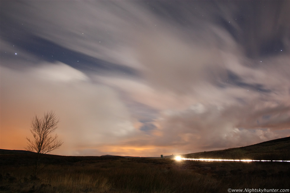 |
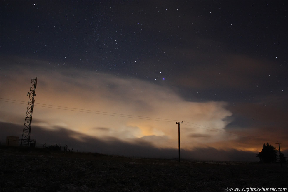
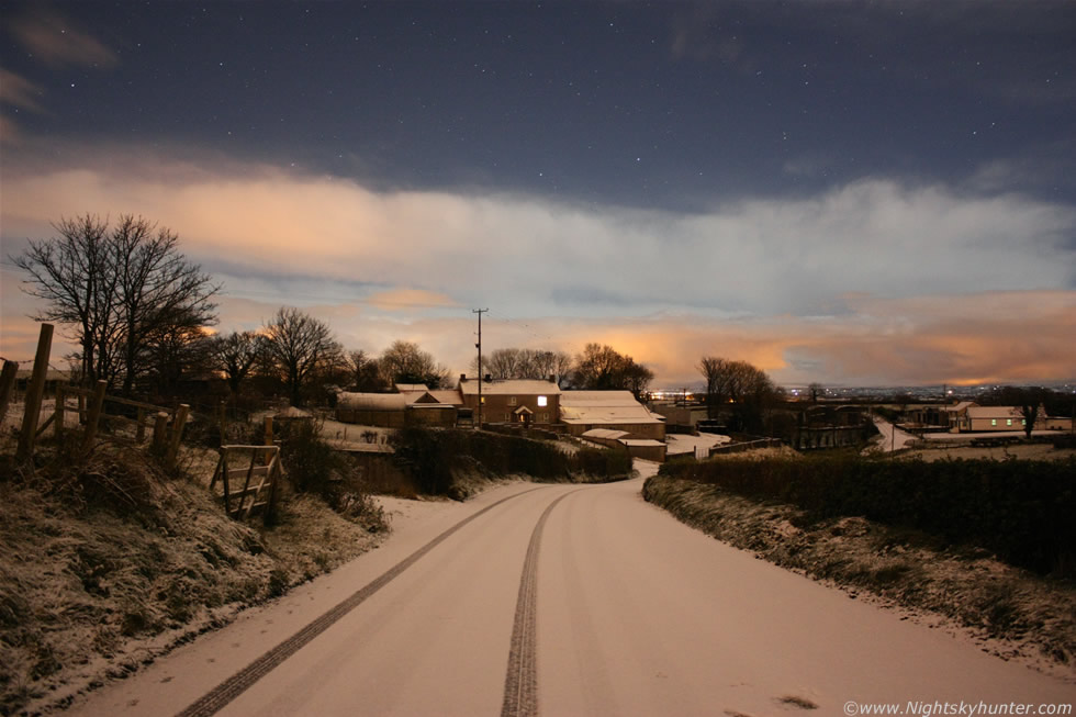
This was the night of the 25th when Arctic air moved over Ireland triggering deep cold air convection and coastal snow showers. My area of N. Ireland was located in the clear zone between the convection although I could see many towers and cbs along the W and E skyline dropping snow showers across the country. I drove to the top of Glenshane Pass with really no idea about what I was looking for as there was no snow here so far but I ended up getting treated to the starry sky filled with distant cumulus/snow showers and an extraordinary array of ice crystal-rich cirrus clouds streaming across the sky in the Nly flow, all of these were lit by a bright waning full Moon in the NE well above the Sperrins which caused the frost to glow on the minor roads. The temp outside was so bitter that I was taken back by it and realised that I was not appropriately dressed for these conditions. Setting up the camera and metal tripod in this polar air was terrible on the fingers. Even so I spent a good hour so so taking exposures of the moonlit clouds and convection. The above image is one example showing the cirrus in association with Vega, Hercules, Ursa Major, and Draco. This is looking NW along the main Glenshane Road where you can see car trails. I was glad to get back in the car again and get warmed up. I knew from here on that things were going to get more exciting and severe.
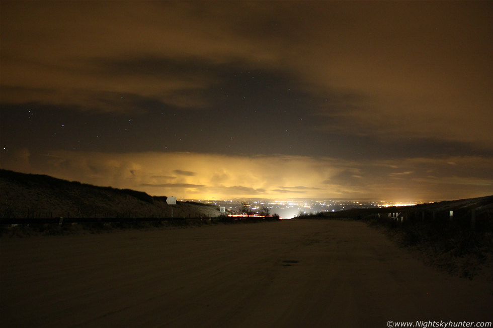 |
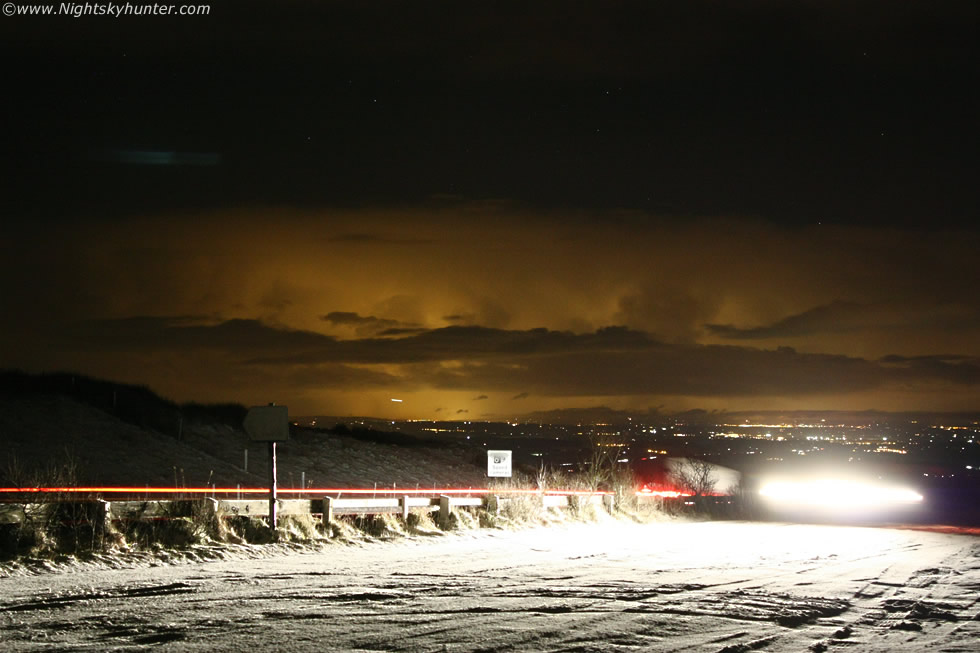
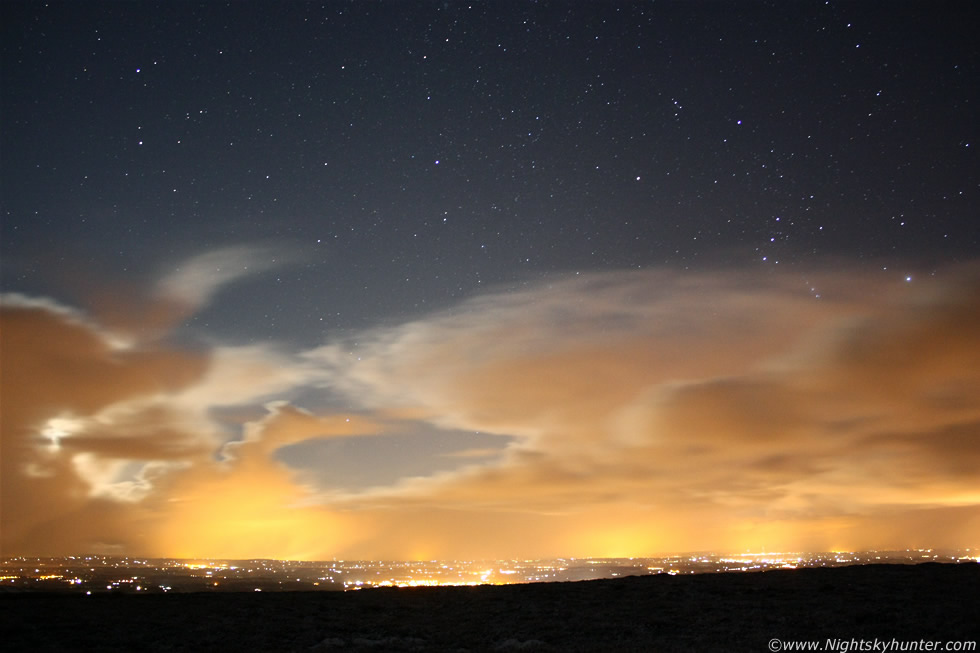
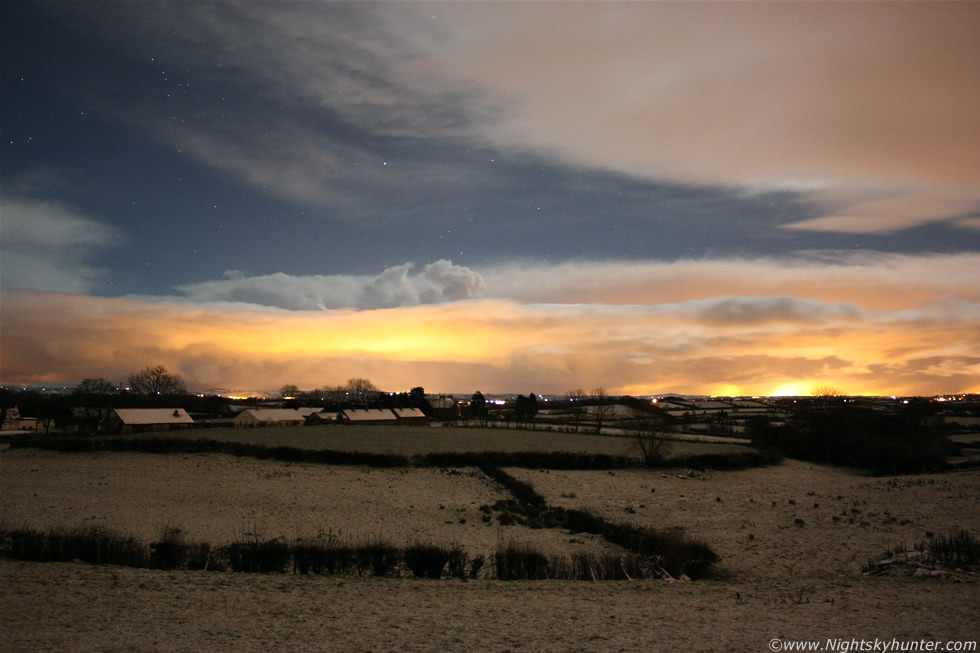
This was the evening of Friday November 26th and Winter had truly arrived bringing with it the first inland snow showers and ice as the temp continued to drop as a Nly flow established itself. ESTOFEX had a convective forecast out for thundersnow along many of the UK/Ireland coastal areas which had my interest. There was several 100 CAPE and freezing upper level temps, sufficient moisture over warm SSTs, numerous troughs and disturbances with convergence zones. The chat on the forums at the time seemed to favor the Irish Sea as a good place for storms. I didn't think much more about as these events tend to be isolated with one or two flashes with nothing to get excited about so I spent the afternoon enjoying the snow. By late evening the forums began to get lively with chat about thunderstorms and thundersnow which was getting very exciting, a quick check on the radar showed numerous echoes all down the entire Irish Sea which really got my attention and I wondered if I might be able to see them from high ground so I drove back up Glenshane again to see what was cooking.
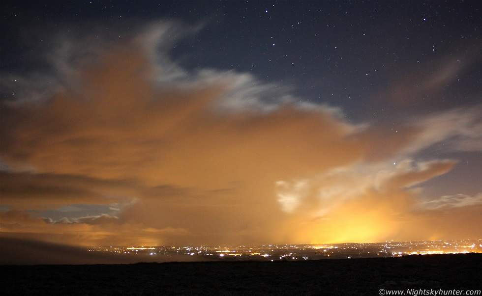
The road was covered in a good dusting of snow and once I reached a high enough vantage point I pulled into the S side of the road into one of the large lay bys there and turned the car around to face E. It was snowing heavily at the time so I could see nothing but big snow flakes swooshing through the air in haphazard fashion like thousands of drunken Bumble Bees. I took some shots out the window of the cars and trucks battling with the snow however one is very restricted with hand held images. I waited and waited until a clearance opened up in the E and the snow stopped for a brief period. It was then that I saw those storms with ease which amazed me considering the distance. The above image is 18mm wide angle and those storms where located over E Co. Antrim and over the Irish Sea so that's approx 60-70 miles away, and yet they looked huge on the skyline!. These are all time exposures taken from the lay by in the frigid conditions. That large train of yellow/orange cloud is a line of large convective cells in the form of towering cumulus and cbs, the image is side-on to the line and with a little imagination you can make out the form of an anvil to the front and rear. To the far L you can see a large tower at the back near Betelgeuse in Orion.
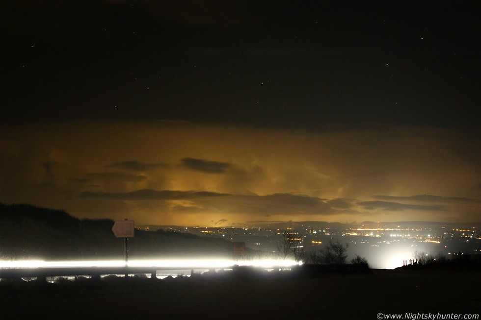 |
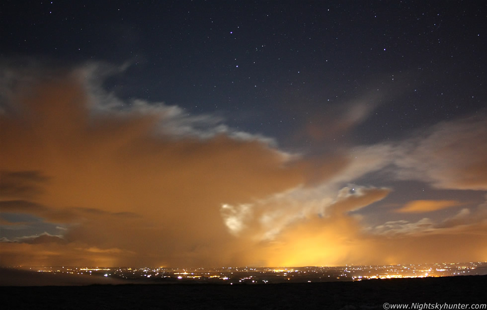
I zoomed the camera in for a closer look, these are 43mm to 55mm using the 18-55mm kit lens which is too slow for this kind of work. A fast 50mm F/1.8 or F/1.4 would have been perfect. With a situation like this you want to expose the scene as quickly as possible to show the structure in the storm clouds without too much motion blur. The faster lens would gather more light and allow for a shorter shutter with greater detail in the clouds along with more stars in the sky. I did what I could with the kit lens and alternated between ISO1600 and 800, exposure times ranged from 4 to 17 sec's. The other issue apart from the freezing air hurting my fingers were car lights, Glenshane is an extremely busy road with an abundance of traffic so I had lights shining into the camera all the time blinding me and ruining the exposure due to lens flares and so fourth. I had to wait until the correct moment to avoid the full-on glare and catch the clouds between cars which was not easy at all, despite this I did settle for some deliberate car trails which added to the scene. This image shows the cloud structure pretty good with big towers and cb calvus type updraughts visible along the side of the anvils as deep convection exploded into life.
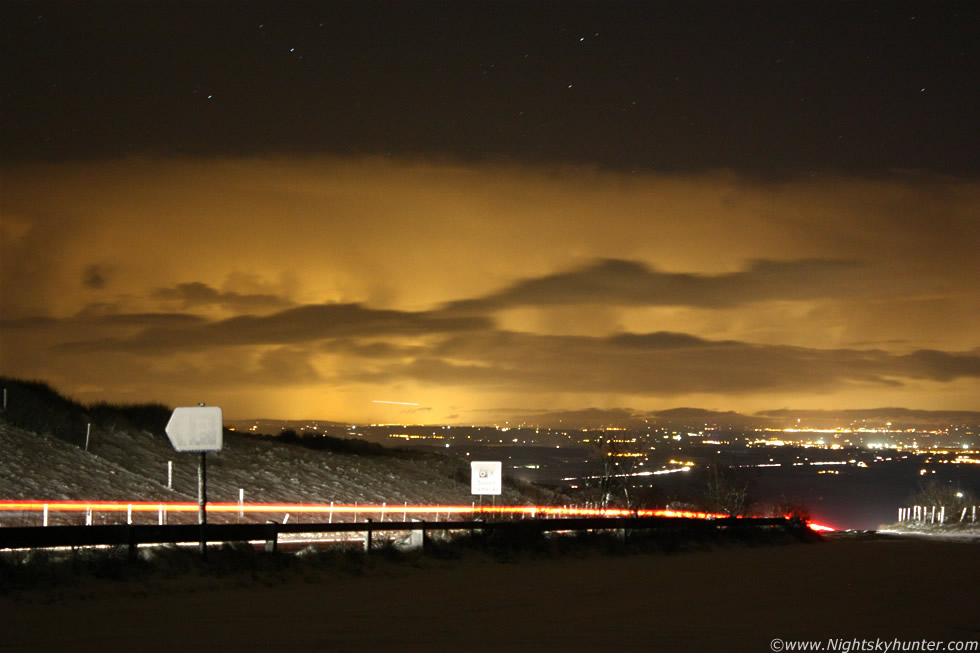 |
In the images the cells are moving from L to R (N to S) down the Irish Sea so I had a perfect view of them. This was impressive because they look so big even at 60-70 miles distance. The closer region of towers are dumping snow showers across E. Antrim. In this longer exposure you can see the trail of a passenger plane leaving the airport. There were very few bright stars on show to get focused so I had to use the distant lights over Antrim instead. The road signs are covered in snow at Glenshane, the passing car headlights did me a favor by lighting them up.
 |
I included this image to show a 4x4 Range Rover which pulled into the lay by I was in. The driver's intentions were just to have fun because he spent his short visit here pulling the hand break throwing the vehicle into a 180 degree spin which he repeated several times. You can see the motion of his head lights in the image. He drove on past me at close range and probably wondered who the nutter was out with the camera in these conditions.
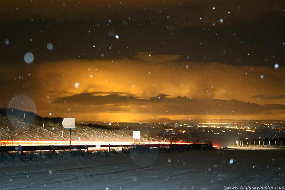 |
Same scene with a longer exposure only this time it began snowing heavily again and my shooting time was numbered so I fired the flash for this last one which shows the falling snow flurry in conjunction with the thundersnow cells to the E in the same frame. It then clouded over and continued to snow, the temp inside the car was getting uncomfortable despite the warm air so I headed back home to warm up. However before I did I couldn't resist the temptation to wait a little longer for a clearance because I was eager to keep an eye on those cells so I changed my mind on the home plan and pulled off the Glenshane Road into the N lay by (L) which is a steep down hill resting area for truck drivers and also a good place to have a picnic, it also provides a nice view point to the E.
I entered the lay by at 10 mph while driving carefully and avoiding any sudden steering, then down to 5 mph and dropped to 2nd gear to reduce wheel spin in the snow. What I didn't know was the snow covered a layer of black ice down the entire road, so even at 5 mph, which was nearly stalling the car, I just kept sliding on down hill, breaks were to the floor and steering was useless, then the car slid at an angle towards the edge, I thought the entire car was going to fall into the valley below where an icy stream passed through. I really thought I was going in and there was absolutely nothing I could to. Amazingly the car stopped at the edge and I got it straightened out, however every time I went forward it slide to the edge again so I had to battle with the steering and very slowly let the car drift forward under semi-control with only a fraction of the clutch engaged, that seemed to control my speed and was just enough to keep me on the road. Another car pulled in behind me and suffered the same fate and together both of us battled with the ice at a Snail's pace until I arrived at the exit to the main road. I was never so glad to get back on the Glenshane Road in my life, that was too close!. It took me 10 min's to navigate down that death trap of a lay by without incident however it felt like half an hour.
 |
I was only at home for 10 min's when Conor McDonald called around eager to do some shooting in the snow and he was thinking of the Glenshane Pass. I told him I had already been up and showed him these images of the cells and he got very interested in seeing the cells for himself. We checked SAT24 and saw that impressive line of convection I had just seen, then brand new cells suddenly exploded with perfect round solid anvils smack bang on the E coast over the Irish Sea and the North Channel not far from Larne so we decided to waste no time and went back out immediately. So for the second time that evening I was back on Glenshane Pass driving through the snow and now that there were two of us we could afford to take more of a chance so we entered the snow-covered road to the S over the Cattle grid and drove along the nasty minor road uphill onto high ground. We stopped at the top and it was obvious from the lack of tracks in the snow that we where the only people to have dared to venture out here in recent hours. The risk was well and truly worth it because the sky was amazing. To our E the skyline was filled with giant storm clouds and the same again to our W, it was difficult to choose what to shot first so we decided on the E line as this was the one we saw on SAT24 before we left the house.
It was absolutely freezing outside with a severe frost however the snow had stopped which gave us a window of opportunity to get images. We climbed over a horribly cold gate and walked through marsh ground until we had a good spot looking E. The view in front gave us an unexpected thrill because due E the waning gibbous Moon had rose and was illuminating a line of strong convection over the E coast. We could see big Turkey towers and anvils moving across a star studded sky with the Moon winking on and off behind passing storm clouds which caused the ground to brighten and fade at regular intervals which added to the special atmosphere. The blue moonlit sky contrasting against the orange lights catching the convection was a really stunning sight. We both raced to set up our tripods and began taking exposures, the above image was my first of the session, the cells are moving N to S (L to R) across the sky. In this image you can see curtains of snow falling across the distant lights of Antrim with the more distant cells behind those over the Irish Sea. Larger cells where visible out of frame to the R just to the L of Slieve Gallion and more can be seen moving into frame from the L near the Moon.
 |
I looked behind me to the W and said WOW out loud and yelled at Conor to look behind him as he was busy shooting the E cells. To our W was a beautiful line of cbs surrounded by rich star fields with the sparkling blue-white gem of Vega above the anvils. The cells seemed to be glowing in the moonlight with various shades of atmospheric colours. These cells were quite beastly in size and where much further away than they might seem on this 18mm image, in fact they where part of a dense group of convective snow cells over the W coast of N. Ireland which is probably a good +50 miles from here. These where moving R to L on the image but in order to shoot them I had to twist the camera around on the tripod then re-adjust the height of all three tripod legs to get leveled - a task made difficult by freezing fingers and the thick spongy snow-covered ground we were standing on which was not tripod friendly. With the exception of the lights from that single house to the R this place is pretty much desolate and in the middle of nowhere and the temp seemed to be dropping further by the minute. This was one of my most favourite scenes from the night.
 |
Swinging the camera back E again and adjusting the tripod for the second time. The exposure was a little long for this one which exhibits much motion blur and rather a intense look to the lights reflecting off the snow curtains. Having said that I still like the image because it contrasts nicely with the stars aloft where the famous constellations of Orion and Gemini can be seen watching the action below. This line of convection, and the new cells to follow, are all part of the convergence line over the Irish Sea which would produce thundersnow all night long.
 |
Then back once again to the W because I couldn't resist another exposure of those distant cells. You can see mammatus forming on the back of the anvil to the RHS, also note the long dark horizontal formation along the bottom of the cell with K-H wave type shape, that's a bank of freezing fog blowing R to L.
 |
Back to the E once again where a huge cell exploded to life. Look at the size of the anvil on that, and just to reiterate the base of that storm was over the Irish Sea some 60 miles away so it's not over land at all although you would be forgiven for thinking it was judging my the lights. The anvil height on this was as good as any day time Summer storm we had seen this year and it kept growing bigger by the minute. Conor and I were very impressed.
 |
The above two exposures are only separated by 2 min's and look at the difference in the height of the anvil during that 120 sec interval. You can make out the huge updraught going into the cell and a flanking line of towers to the LHS as the thundersnow storm sailed majestically across the horizon from L to R. At this point in time Conor and I were more than happy that we had made the effort to get up here through this bad terrain. Here we where standing on a dark mountain almost up to our knees in spongy marsh covered in snow which was lit by the rising Moon, all this in between acts of snow showers and under a severe frost with big thunderheads dominating the skyline in front and behind us brilliant Stars winked while the Moon played peek a boo from behind towering updraughts as thundersnow affected parts of the country, yet this was November, it was difficult to take in.
Time was running out fast though, remember that K-H type fog bank three images up?, now look to the far LHS on the above image. That's that wall of freezing fog now heading our way, Conor spotted it first and pointed out how dark the environment was getting and as we watched we could see distant lights being extinguished as the fog advanced towards us, it looked horrible however we kept taking exposures for as long as we could until the fog obscured the big cell to the E then we packed up and jogged back to the car with hands freezing and sore as the fog swallowed us up. We enjoyed the mercy of the warm air once the car warmed up and on the head lights in front we could see a fogbow. After 10 min's the fog cleared through so we got back out again onto the narrow snow-covered road and watched the convection.
That anvil in the E had grown so high during that 10 min's that we could see it at the zenith!. Then Conor saw a bright flash of lightning to the SE to the L of Slieve Gallion then we both witnessed another flash in the same direction. No doubt someone on the coast was getting treated to a great thundersnow display at close range. It was getting late so we decided to go back home however that wasn't as easy as we thought, when I started the car the spinning wheels pulled the car towards the ditch because the road slanted in that direction, Conor had to go out and push the car back to the centre of the road while I tried to accelerate, the pushing and bouncing of the car eventually caused the wheels to gain purchase and we were on our way down a step narrow country road covered with ice and snow, normally it would take 5 min's going down this road but this time it took over 20.
 |
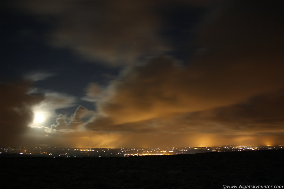
Later in the night I checked the forums and saw very excited chat about amazing thunderstorms/thundersnow happening all across the Irish Sea and along the E coast of Ireland and N. Ireland which really got my attention. The consensus from the chat was that is was a rare and significant event taking place so it warranted investigating on my part. The storms where very far away from here so there was no chance I could get close to them as fuel was low in the car and the snow and ice were just too treacherous for a long drive at this hour of the night so I decided that I would watch the show from Maghera where I would undoubtedly see the flashes. With camera bag and tripod in hand I walked through the snow into the deep countryside which was a round trip of four miles on foot. The extra effort was worth it though because I found an excellent location away from street lights on high ground in the middle of nowhere where I could get peace and quiet although there wasn't a chance in hell of meeting anyone out here in this weather.
I cant even begin to describe how amazing this night was. At 01.00 in the morning the countryside was absolutely dead calm, I mean truly silent with not even a single noise from Sheep or Cattle so everything seemed shockingly still. The only sound was the barely audible hiss from my breath condensing into a milky cloud in the frigid air complimented by the periodic crunch or squeak from my movement on the snow. The ground was completely covered in a thick carpet of beautiful dry snow and high in the sky a brilliant waning Moon cast its unearthly glow across the snow fields turning them into a strange cream or off-white colour punctuated by glittering ice crystals - a scene totally unique to this special marriage between snow and moonlight which made my world seem like a dream. Above was an 80% clear sky filled with blinking beacons as the brightest Winter stars flickered due to the effect of scintillation in the freezing air.
Now and again a glowing cloud formation would set adrift from the rest and lazily sail past the Moon generating a colourful corona. The clouds themselves seemed to boast an intense white colour with their their bellies lit orange and gold by some distant light. However strangest of all was the spellbounding deep blue colour in the clear sky which varied in tone with height in the sky which contrasted beautifully with the warm colours. This was no doubt an optical effect caused by scattered moonlight getting filtered by the reflective and refractive properties of the moonlight passing through ice crystals in the atmosphere and it's reflection off the snow on the ground which would return the ghostly light back into the sky. I'm sure I have seen this effect last year however never before have I seen it so vividly. The above exposure is looking N however it doesn't come close to capturing what I experienced. The stage was then set for an unforgettable night.
 |
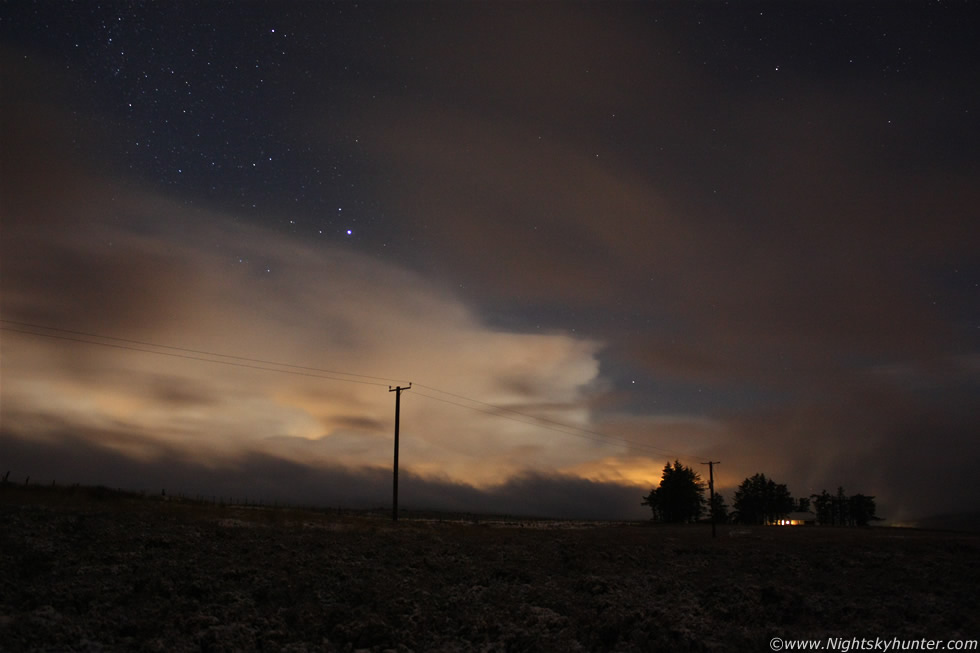
For the next several hours I was treated to the best night time lightning display I have seen this year and although the storms where too distant to hear the thunder I could see the lightning quite easily. At any one time there appeared to be two huge thunderstorms flashing away, one was to the E not far from Larne, and other in the SE near Dublin, both where again located over the Irish Sea and moving down the North Channel between Ireland and Britain from N to S as trains of cells which turned extremely electrical due to the freezing upper air and superb lapse rates. The image above is an exposure taken looking E, in the foreground are fields with snow, in the distance are the huge thunderheads over the Irish Sea, this was just one of two areas producing lightning flashes and both the snow and the cells were lit brightly by the Moon, combine this with my earlier description of the sky and you can see why this tuned into my most magical sky experience of 2010 to date.
The image is looking NE to E, the storms are moving L to R, and the lead storm is out of frame to the R. You can see the huge anvil side-on taking up almost the entire length of the 18mm frame and if you take into account that the storm was 60-70 miles distant you can really sense the size of the beast. The cells were dropping snow while flickering with lightning so this was another thundersnow event. On my side of the anvil is a row of cu with a big updraught tower set against the storms flank with mid level cloud obscuring part of the storm. If you can picture this sight in the freezing temps with snow all around with lightning, moonlit cells, with Moon and stars above then you can see why the experience was so amazing and surreal. Most of the lightning was a vivid orange colour, all the flashes were incredibly bright with numerous double flashes when several bolts fired at the same time. Despite the huge distance I could actually see great structure in some of the in-cloud bolts (I-c) which lit the inside of the cell and anvil up like a light bulb and at + 60 miles distance those bolts must have been wicked and covering much of the visible sky for those lucky enough to be at close range.
I watched the action for several hours until I could stick the cold no longer then began the walk home back through the snow with the sky flashing the entire time, even when in bed I watched the lightning from my bedroom window until I fell asleep at 05.00 UT. This was the first of six days and nights of thundersnow over Ireland with this night being the most epic of them all. When I awoke the next day the previous night seemed like a dream however the excited chat on the forums confirmed that it was all very real. Those who where closer to the action got stunning images and video, others reported lightning all night long and even by the early afternoon after the main event there was still thundersnow in that same area. This was a wild show and one of the most significant thundersnow events to affect this country in many years. I never was close enough to get the full show however the view I had near home while standing in those snow fields was a memory I will always cherish!.
Thundersnow also known as a Winter Thunderstorm or a Thunder Snowstorm is a particularly rare meteorological phenomenon that includes the typical behavior of a thunderstorm, but with snow falling as the primary precipitation instead of rain. It commonly falls in regions of strong upward motion within the cold sector of extratropical cyclones between autumn and spring when surface temperatures are most likely to be near or below freezing. Variations exist, such as thundersleet, where the precipitation consists of sleet rather than snow.
There are usually three forms of thundersnow:
1) A normal thunderstorm on the leading edge of a cold front or warm front that either forms in a winter environment or one which runs into cool air and maintains the precipitation as snow.
2) A heavy synoptic snowstorm in the comma head of an extratropical cyclone that sustains strong vertical mixing which allows for favorable conditions for lightning and thunder to occur.
3) A lake effect or ocean effect thunderstorm which is produced by cold air passing over relatively warm water, this effect commonly produces snow squalls over the Great Lakes.
One unique aspect of thundersnow is that the snowfall acts as an acoustic suppressor of the thunder. The thunder from a typical thunderstorm can be heard many miles away, while the thunder from thundersnow can usually only be heard within a two to three kilometer radius from the lightning. In the United States, March is their peak month of formation, and on average, only three events are reported per year. A thundersnow event occurred on January 28, 2004 across central and southern Britain as a result of a squall line embedded in air of Arctic origin. The squall resulted in a sudden drop in temperature and pressure along with brief but heavy snowfall and blue lightning, and even a tornado near the town of Bath. This event is particularly notable because of the local temperate maritime climate, which usually prevents such extremes of weather.
Martin McKenna